Project: Forecasting the effects of land use/land cover change on ecosystem carbon across the U.S.
Project:
Forecasting the effects of land use/land cover change on ecosystem carbon across the U.S.
Client: U.S. Geological Survey
Year: 2013 - present
Focus Areas: Landscape Change, Ecosystem Services (Carbon Sequestration)
Project Overview
Integrated models of land use/land cover change and ecosystem carbon dynamics are required in order to forecast the effects of future land management, including natural climate solutions, on greenhouse gas emissions. Working with scientists in the U.S. Geological Survey's LandCarbon program, our team at ApexRMS has developed the Land Use and Carbon Simulator (LUCAS; Sleeter et al. 2018, Sleeter et al. 2022), a stochastic model forecasting the effects of past and future land use/land cover change on ecosystem carbon dynamics.
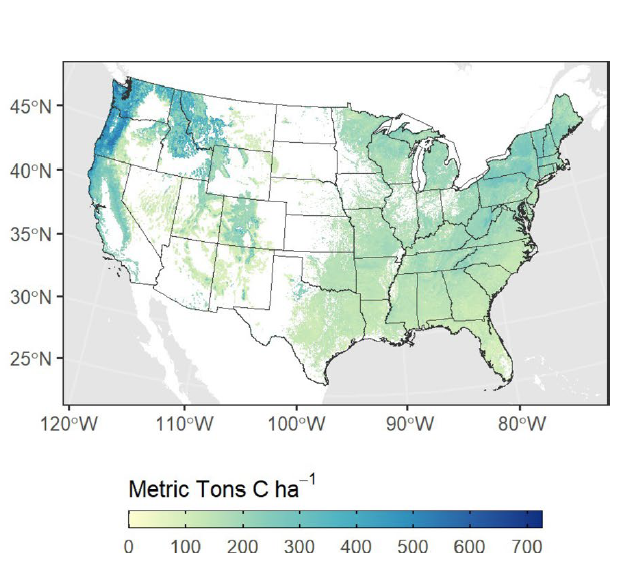
LUCAS is unique in its ability to generate forecasts that integrate landscape change and carbon dynamics spatially, including estimates of uncertainty, at fine resolutions (e.g. 30 meter) over large geographic (e.g. statewide and national; Figure 1) areas. Because LUCAS runs within the SyncroSim software modeling environment, it comes with the built-in ability to compare alternative “what-if” scenarios regarding the effects of possible future changes in land management and climate change on greenhouse gas emissions – a key requirement for effectively comparing and contrasting the carbon consequences of candidate natural climate solutions.
Since its initial release in 2015, LUCAS has been used to generate integrated projections of land cover change and carbon balance across a wide range of spatial scales and extents, including: (1) historical projections of carbon balance for the conterminous U.S.; (2) statewide projections of future carbon balance for California and Hawaii, including effects of climate change and assessment of alternative natural climate solutions; (3) regional projections of historical carbon balance for the Mississippi River Delta; and (4) local projections of wetland carbon dynamics for the Great Dismal Swamp National Wildlife Refuge.
Client: U.S. Geological Survey
Year: 2013 - present
Focus Areas: Landscape Change, Ecosystem Services (Carbon Sequestration)
Tools: SyncroSim, ST-Sim, LUCAS
Project Overview
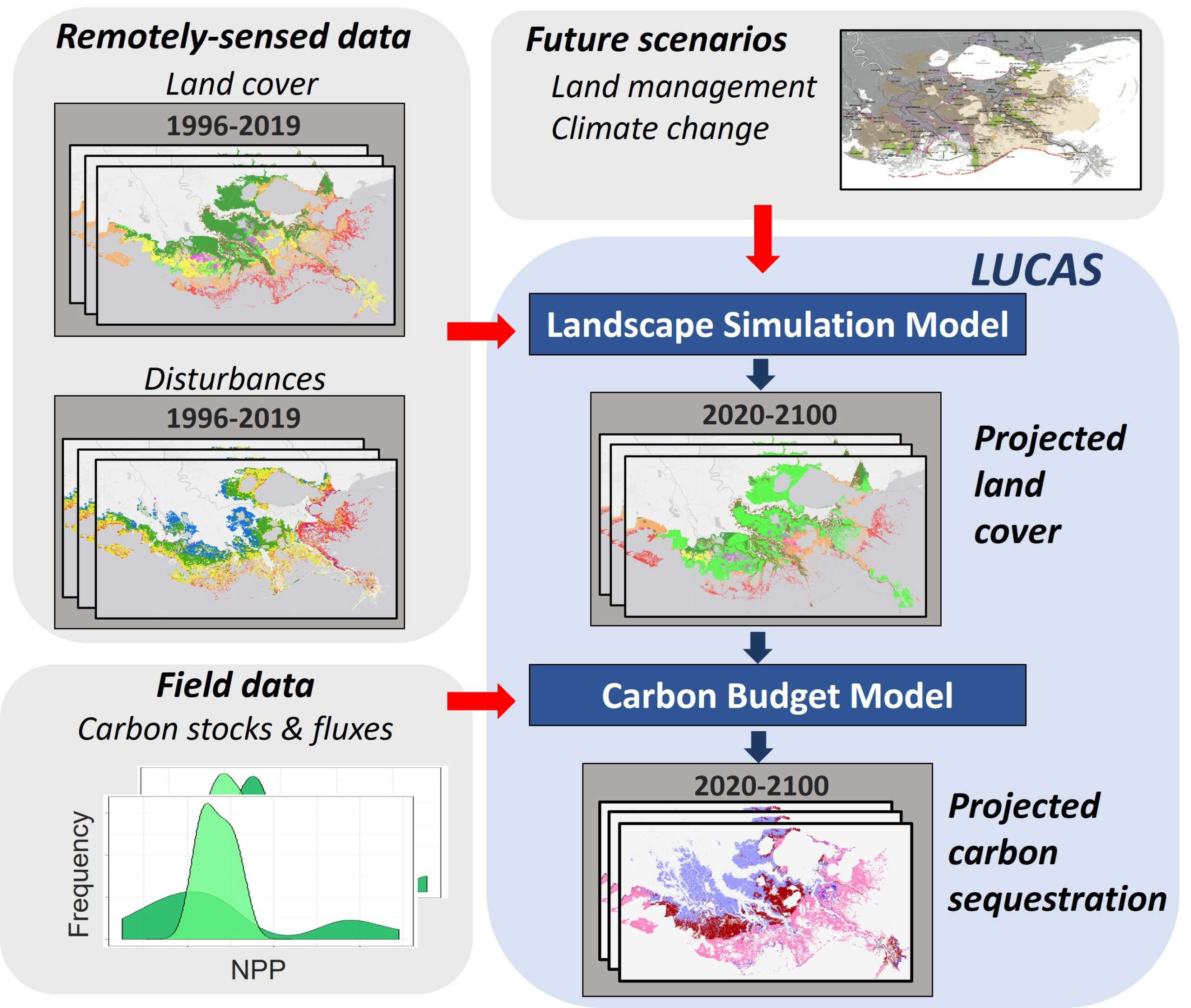
Integrated models of land use/land cover change and ecosystem carbon dynamics are required in order to forecast the effects of future land management, including natural climate solutions, on greenhouse gas emissions. Working with scientists in the U.S. Geological Survey's LandCarbon program, our team at ApexRMS has developed the Land Use and Carbon Scenario Simulator (LUCAS; Sleeter et al. 2018, Sleeter et al. 2022), a stochastic model forecasting the effects of past and future land use/land cover change on ecosystem carbon dynamics.
LUCAS is unique in its ability to generate forecasts that integrate landscape change and carbon dynamics spatially, including estimates of uncertainty, at fine resolutions (e.g. 30 meter) over large geographic (e.g. statewide and national; Figure 1) areas. Because LUCAS runs within the SyncroSim software modeling environment, it comes with the built-in ability to compare alternative “what-if” scenarios regarding the effects of possible future changes in land management and climate change on greenhouse gas emissions – a key requirement for effectively comparing and contrasting the carbon consequences of candidate natural climate solutions.
Since its initial release in 2015, LUCAS has been used to generate integrated projections of land cover change and carbon balance across a wide range of spatial scales and extents, including: (1) historical projections of carbon balance for the conterminous U.S.; (2) statewide projections of future carbon balance for California and Hawaii, including effects of climate change and assessment of alternative natural climate solutions; (3) regional projections of historical carbon balance for the Mississippi River Delta; and (4) local projections of wetland carbon dynamics for the Great Dismal Swamp National Wildlife Refuge.

Model Structure
At its core, LUCAS consists of two integrated sub-models: a spatially-explicit landscape simulation model and a carbon budget model (Figure 2). For its landscape change component, LUCAS uses the ST-Sim state-and-transition simulation model (Daniel et al. 2016) to capture land use/land cover dynamics. A key feature of ST-Sim is its flexibility with respect to the ecological systems it can represent, allowing it to generate “wall-to-wall” land use/land cover forecasts for landscapes consisting of mixed ecological communities. The landscape change component of LUCAS is typically parameterized first using national datasets, which in the U.S. include remotely-sensed land cover assessments (such as NLCD, C-CAP and LC MAP) and national disturbance data (from sources such as LANDFIRE and MTBS). National datasets can then be further supplemented with local and regional land cover and disturbance data, where available.
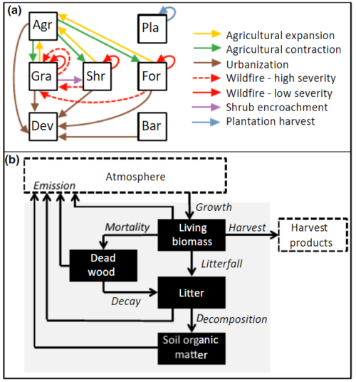
The carbon budget sub-model within LUCAS tracks any number of user-defined carbon pools over time, with changes in these pools driven by fluxes due to various ecological processes, disturbances, and management actions (Daniel et al. 2018; Figure 3). Annual fluxes in carbon pools can be tracked for multiple user-defined land cover classes, such as forests, grasslands, shrublands and wetlands, including, importantly, fluxes in carbon resulting from both disturbances and transitions between land cover classes. The flux rates for the LUCAS carbon sub-model can be parameterized in various ways, including through linkages to other models, using literature sources, or by fitting flux rates to field measurements for specific ecosystems. For example, past work has captured forest carbon dynamics through the integration of the IPCC Tier 3 CBM-CFS3 carbon budget model (Sleeter et al. 2022), shrubland and grassland dynamics have been modeled using simulations from the IBIS biogeochemical model (Sleeter et al. 2018), and wetland carbon dynamics have been characterized directly from detailed field measurements (USGS 2021).


Additional Information
National U.S. terrestrial carbon assessment: Sleeter, B., Liu, J., Daniel, C. J., Rayfield, B., Sherba, J., Hawbaker, T.J., Zhu, Z., Selmants, P.C., and Loveland, T.R. 2018. Effects of contemporary land-use and land-cover change on the carbon balance of terrestrial ecosystems in the United States. Environmental Research Letters.
National U.S. forest carbon assessment: Sleeter, B., Frid, L., Rayfield, B., Daniel, C., Zhu, Z., and Marvin, D.C. 2022. Operational assessment tool for forest carbon dynamics for the United States: a new spatially explicit approach linking the LUCAS and CBM-CFS3 models. Carbon Balance and Management.
National U.S. coastal wetland carbon assessment: U.S. Geological Survey Wetland Carbon Working Group: Improving Methodologies and Estimates of Carbon and Greenhouse Gas Flux in Wetlands [Website].
Long-term regional projections of ecosystem carbon: Sleeter, B. M., Marvin, D. C., Cameron, D. R., Selmants, P. C., Westerling, L., Kreitler, J., Daniel, C. J., Liu, J., & Wilson, T. S. 2019. Effects of 21st century climate, land use, and disturbances on ecosystem carbon balance in California. Global Change Biology.
Regional assessment of natural climate solutions: Marvin, D. C., Sleeter, B. M., Cameron, D. R., Nelson, E., & Plantinga, A. J. 2023. Natural climate solutions provide robust carbon mitigation capacity under future climate change scenarios. Scientific Reports.
Regional carbon balance of wetlands: Daniel, C. J., LaFosse Stagg, C., Ward, E. J., Rayfield, B., & Sleeter, B. 2022. Quantifying the effect of changes in land use and land cover on the carbon balance of coastal wetlands in the Mississippi River Delta. Poster presentation at the 2022 Ecological Society of America Annual Meeting, Montreal QC.
Local-scale land management of wetlands: Sleeter, R., Sleeter, B. M., Williams, B., Hogan, D., Hawbaker, T., & Zhu, Z. 2017. A carbon balance model for the Great Dismal Swamp ecosystem. Carbon Balance and Management.
Stand-alone forest carbon budget model: ST-Sim CBM-CFS3 SyncroSim Package.
Linking LUCAS to forest carbon budget model: Sleeter, B. M., Frid, L., Rayfield, B., Daniel, C. J., Zhu, Z., & Marvin, D. C. 2022. Operational assessment tool for forest carbon dynamics for the United States: a new spatially explicit approach linking the LUCAS and CBM-CFS3 models. Carbon Balance and Management.
Hands-on demonstration of LUCAS software: Sleeter, B. 2017. Climate, land use and wildfire impacts on ecosystem carbon balance in California. Oral presentation at the 2017 ST-Sim User Conference, Fort Collins CO [YouTube video].
Downloading & installing LUCAS software: LUCAS SyncroSim Package [Website].
Photo credit: Sergio Merino, USGS
Additional Information
National U.S. terrestrial carbon assessment: Sleeter, B., Liu, J., Daniel, C. J., Rayfield, B., Sherba, J., Hawbaker, T.J., Zhu, Z., Selmants, P.C., and Loveland, T.R. 2018. Effects of contemporary land-use and land-cover change on the carbon balance of terrestrial ecosystems in the United States. Environmental Research Letters.
National U.S. coastal wetland carbon assessment: U.S. Geological Survey Wetland Carbon Working Group: Improving Methodologies and Estimates of Carbon and Greenhouse Gas Flux in Wetlands [Website].
Long-term regional projections of ecosystem carbon: Sleeter, B. M., Marvin, D. C., Cameron, D. R., Selmants, P. C., Westerling, L., Kreitler, J., Daniel, C. J., Liu, J., & Wilson, T. S. 2019. Effects of 21st century climate, land use, and disturbances on ecosystem carbon balance in California. Global Change Biology.
Regional assessment of natural climate solutions: Marvin, D. C., Sleeter, B. M., Cameron, D. R., Nelson, E., & Plantinga, A. J. 2023. Natural climate solutions provide robust carbon mitigation capacity under future climate change scenarios. Scientific Reports.
Regional carbon balance of wetlands: Daniel, C. J., LaFosse Stagg, C., Ward, E. J., Rayfield, B., & Sleeter, B. 2022. Quantifying the effect of changes in land use and land cover on the carbon balance of coastal wetlands in the Mississippi River Delta. Poster presentation at the 2022 Ecological Society of America Annual Meeting, Montreal QC.
Local-scale land management of wetlands: Sleeter, R., Sleeter, B. M., Williams, B., Hogan, D., Hawbaker, T., & Zhu, Z. 2017. A carbon balance model for the Great Dismal Swamp ecosystem. Carbon Balance and Management.
Stand-alone forest carbon budget model: ST-Sim CBM-CFS3 SyncroSim Package.
Linking LUCAS to forest carbon budget model: Sleeter, B. M., Frid, L., Rayfield, B., Daniel, C. J., Zhu, Z., & Marvin, D. C. 2022. Operational assessment tool for forest carbon dynamics for the United States: a new spatially explicit approach linking the LUCAS and CBM-CFS3 models. Carbon Balance and Management.
Hands-on demonstration of LUCAS software: Sleeter, B. 2017. Climate, land use and wildfire impacts on ecosystem carbon balance in California. Oral presentation at the 2017 ST-Sim User Conference, Fort Collins CO [YouTube video].
Downloading & installing LUCAS software: LUCAS SyncroSim Package [Website].
Photo credit: Sergio Merino, USGS


