Project: Wildlife Corridor Analysis for the Cootes to Escarpment EcoPark System
Clients: Royal Botanical Gardens, Implementing Partner for the Cootes to Escarpment EcoPark System
Year: 2020
Focus Area: Ecosystem Services (Habitat Connectivity)
Clients: Royal Botanical Gardens,
Implementing Partner for the Cootes to Escarpment EcoPark System
Year: 2020
Focus Area: Ecosystem Services (Habitat Connectivity)
Project Overview:
Protecting and restoring habitat connectivity is a widespread strategy for achieving biodiversity conservation. Greater habitat connectivity means that wildlife can move between suitable habitat patches and gain access to the best available mates, nesting sites, and food resources. Habitat connectivity is also important to maintain genetic diversity within wildlife populations and to facilitate seasonal and climate-driven migrations across the landscape.
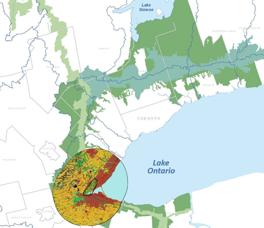
The goal of this wildlife corridor mapping study is to support biodiversity conservation and management activities in the Cootes to Escarpment EcoPark System by identifying habitat patches and movement corridors that promote terrestrial habitat connectivity. The Cootes to Escarpment EcoPark System area is one of Canada’s biodiversity hotspots, a complex landscape of protected lands, open space, urban development, and other uses at the western end of Lake Ontario, in the Greater Toronto Area (Figure 1). We used two complementary connectivity analysis approaches:
1) A generalized approach which identified probable movement corridors for forest- and wetland-dwelling wildlife across the Cootes to Escarpment EcoPark System. We mapped the permeability (or ‘resistance’) of the landscape for animals that avoid unnatural landscape features such as roads and developed land and applied circuit connectivity methods to account for all potential paths across and within the EcoPark System to identify probable movement corridors.
2) A species-specific approach identifying components of connectivity at the species-level (habitat suitability and habitat patch importance for landscape connectivity). Blanding’s turtle, northern short-tailed shrew, and white-tailed deer were selected to reflect the local diversity in terrestrial habitat and connectivity needs. We summarized maps across all species to identify the most important habitat patches for maintaining a connected network of habitat within the EcoPark System based on habitat preferences and dispersal abilities.
The results of the generalized and species-specific connectivity analyses were integrated into a single map that identifies locations within Cootes to Escarpment EcoPark System that could be managed to benefit connectivity for a wide range of species.

Landscape context for the Cootes to Escarpment EcoPark System focal area and 20 km buffer showing Ontario's Greenbelt around the Greater Toronto Area in Southern Ontario, Canada.
Additional Information:
Source Code for Wildlife Corridor Analysis Project
Photo credit: Peter Kelly
Project:
Wildlife Corridor Analysis for the Cootes to Escarpment EcoPark System
Clients: Royal Botanical Gardens, Implementing Partner for the Cootes to Escarpment EcoPark System
Year: 2020
Focus Area: Ecosystem Services (Habitat Connectivity)
Project Overview:
Protecting and restoring habitat connectivity is a widespread strategy for achieving biodiversity conservation. Greater habitat connectivity means that wildlife can move between suitable habitat patches and gain access to the best available mates, nesting sites, and food resources. Habitat connectivity is also important to maintain genetic diversity within wildlife populations and to facilitate seasonal and climate-driven migrations across the landscape.
The goal of this wildlife corridor mapping study is to support biodiversity conservation and management activities in the Cootes to Escarpment EcoPark System by identifying habitat patches and movement corridors that promote terrestrial habitat connectivity. The Cootes to Escarpment EcoPark System area is one of Canada’s biodiversity hotspots, a complex landscape of protected lands, open space, urban development, and other uses at the western end of Lake Ontario, in the Greater Toronto Area (Figure 1). We used two complementary connectivity analysis approaches:
1) A generalized approach which identified probable movement corridors for forest- and wetland-dwelling wildlife across the Cootes to Escarpment EcoPark System. We mapped the permeability (or ‘resistance’) of the landscape for animals that avoid unnatural landscape features such as roads and developed land and applied circuit connectivity methods to account for all potential paths across and within the EcoPark System to identify probable movement corridors.
2) A species-specific approach identifying components of connectivity at the species-level (habitat suitability and habitat patch importance for landscape connectivity). Blanding’s turtle, northern short-tailed shrew, and white-tailed deer were selected to reflect the local diversity in terrestrial habitat and connectivity needs. We summarized maps across all species to identify the most important habitat patches for maintaining a connected network of habitat within the EcoPark System based on habitat preferences and dispersal abilities.
The results of the generalized and species-specific connectivity analyses were integrated into a single map that identifies locations within Cootes to Escarpment EcoPark System that could be managed to benefit connectivity for a wide range of species.

Landscape context for the Cootes to Escarpment EcoPark System focal area and 20 km buffer showing Ontario's Greenbelt around the Greater Toronto Area, the Niagara Escarpment, and the Oak Ridges Moraine.
Additional Information:
Source Code for Wildlife Corridor Analysis Project
